Jampui Hills (Tripura), April 27: The scenic landscape of Tlaksih village in North Tripura has transformed into a zone of distress and despair. For over a century, this village stood as a testament to the heritage of the Jampui Hills.
Today, it stands on the brink of collapse. Local landowners and farmers are now locked in a bitter standoff with the National Highways & Infrastructure Development Corporation Limited (NHIDCL). They allege that the expansion of National Highway 44A (NH44A) has ignored their fundamental land rights and triggered a localized environmental catastrophe.
Broken Promises and Expanding Boundaries
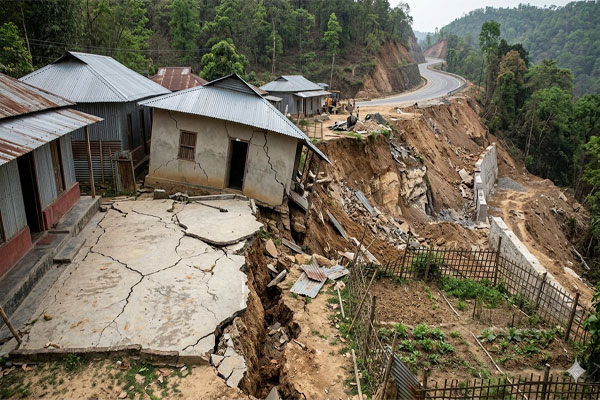
The conflict centers on the deviation from original project blueprints. Initially, authorities assured villagers that the highway corridor would occupy a 30-meter stretch. However, residents claim the construction footprint has ballooned to over 50 meters in several areas. This unauthorized expansion has swallowed fertile plantations and private ancestral land without any formal acquisition process.
“We were promised a development project, but we received a disaster,” one local farmer shared. Despite filing multiple complaints with the Sub-Divisional Magistrate (SDM) in Kanchanpur since 2023, the villagers remain unheard. They claim that official damage assessment reports have gathered dust for three years. This administrative bottleneck has left hundreds of affected individuals in a state of financial and emotional limbo.
The Human Cost: Graves, Schools, and Homes
The physical impact on Tlaksih is harrowing. Continuous land subsidence and deep structural cracking have rendered the eastern portion of the village uninhabitable. To date, around 15 households have lost their homes, forcing families to seek shelter elsewhere. Furthermore, eight acres of vital plantation land—the primary source of income for these hill communities—now lie in ruins.
Perhaps the most painful aspect of this crisis involves the village cemetery. Approximately 30 graves were damaged due to soil shifts. This forced families to exhume the remains of their loved ones and reinter them on temporary, donated plots. Additionally, the village’s only government school has been abandoned. Large cracks in the walls made the structure a death trap for students, effectively halting local education.
News Analysis: A Pattern of Himalayan-Style Fragility
This crisis in the Jampui Hills reflects a growing trend across Northeast India where rapid infrastructure development meets fragile hill topography. Historically, the Jampui range is known for its sedimentary rock layers, which are highly susceptible to “slope failure” when the toe of a hill is cut for road widening.
The Tlaksih situation highlights a critical gap in local governance: the failure to balance engineering requirements with geological sensitivity. By labeling the event a “natural calamity” under the State Disaster Response Fund (SDRF) rather than acknowledging it as a construction-induced “man-made disaster,” the administration may be attempting to limit its financial liability. This tactic, however, erodes the trust between the indigenous Mizo communities of Jampui and the state government.
Quick Glance: The Tlaksih Crisis
| Impact Category | Details of Loss/Issue |
| Displaced Families | 15 Households forced to relocate |
| Agriculture | 8 Acres of plantation land destroyed |
| Infrastructure | 1 Govt School abandoned; NH44A hazardous |
| Social Impact | 30 Graves exhumed and moved |
| Key Allegation | Land usage exceeded 30m corridor to 50m+ |
Intimidation and Altered Boundaries
Tensions reached a breaking point recently during the construction of new retaining walls. Villagers allege that NHIDCL is utilizing additional private land without offering a single rupee in compensation. When residents attempted to block the work, some claimed they were met with threats of legal action and police intervention.

A stakeholders’ meeting was held on January 20, 2026, where officials offered verbal assurances. Yet, three months later, those promises remain unfulfilled. Instead, a fresh resurvey is underway, which many fear is a tactic to further delay the payout of rightful dues. For the people of Tlaksih, the road to “connectivity” has unfortunately become a road to ruin.
Frequently Asked Questions (FAQ)
- What is the main cause of the dispute in Tlaksih?
The dispute involves NHIDCL using more land than originally agreed upon (50 meters instead of 30 meters) for NH44A and failing to pay compensation for the extra land and subsequent damages.
- Why are the villagers calling it a “man-made disaster”?
Residents argue the land subsidence was caused by improper hill cutting and construction techniques by NHIDCL, rather than natural environmental factors.
- Has the government provided any relief?
Limited assistance has been offered under the State Disaster Response Fund (SDRF), but villagers argue this is insufficient to cover the total loss of homes and livelihoods.
- What happened to the village school?
The government-run school in Tlaksih was declared unsafe and abandoned due to massive cracks caused by the shifting soil near the highway site.