Overview: Nagaland University Study
Agartala/Kohima: Researchers at Nagaland University are advocating for advanced geospatial technology and GIS-based modelling to address the escalating crisis of soil erosion in the Northeast Hills.
By focusing on scientific watershed management, the study aims to protect regional biodiversity, stabilize hilly terrains, and secure long-term agricultural productivity.
Quick Glance: Key Highlights
-
Technology First: Use of Revised Universal Soil Loss Equation (RUSLE) and GIS to map erosion hotspots.
-
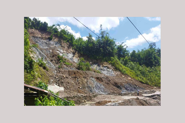
Critical Zones: Steep slopes, mining areas, and croplands identified as high-risk “erosion hotspots.”
-
Core Solution: Implementation of Integrated Watershed Management (IWM) combining biological and mechanical measures.
-
Global Scalability: The framework is designed to be adaptable for similar hilly terrains worldwide.
Geospatial Tech: Fighting Soil Erosion in NE Hills
In a breakthrough for environmental conservation in the Eastern Himalayas, researchers at Nagaland University have unveiled a scientific roadmap to tackle the chronic issue of soil erosion in the hills of the NE Region.
By leveraging geospatial technology, the team seeks to provide a data-driven alternative to traditional land management. The aim is to ensure the unique topography of North East India remains resilient against both climate change and human intervention.
Soil erosion has shifted from a localized farming issue to a major ecological threat. The eastern Himalayan region faces a volatile mix of steep inclines, torrential rainfall, and rapid deforestation.
Experts note that shifting cultivation (Jhum), unorganized mining, and infrastructure projects like road construction have further destabilized the soil.
Scientific Methodology: The RUSLE-GIS Model
The research, published in a prestigious Springer Nature journal, centered on the Siji watershed within the Gai River Basin of Assam. This area serves as a microcosm for the broader North East, exhibiting extreme vulnerability to sediment transport.
To quantify the damage, the team utilized the Revised Universal Soil Loss Equation (RUSLE). This mathematical model evaluates five critical environmental variables:
| Factor | Description | Impact on Erosion |
| Rainfall Intensity | Frequency and volume of precipitation | High in NE India; triggers runoff |
| Soil Erodibility | Physical characteristics of the soil | Varies by mineral composition |
| Topography | Steepness and length of slopes | Steep hills accelerate soil loss |
| Land Cover | Vegetation versus barren land | Dense forests provide 90% protection |
| Conservation | Existing man-made barriers | Critical for reducing sediment flow |
Identifying Erosion Hotspots
The findings, co-authored by Prof. M. S. Rawat and scholar Tulumoni Gogoi, indicate a stark contrast between protected and disturbed lands. While dense forest canopies naturally mitigate erosion, areas undergoing road development or mining show “extremely high” erosion rates.
These disturbances don’t just deplete the land; they threaten local ecosystems and water purity by increasing sediment loads in rivers.
IWM: The Way Forward
Prof. Rawat emphasizes that “uniform solutions” are no longer effective. Instead, the study advocates for Integrated Watershed Management (IWM).
“We recommend a dual approach,” Prof. Rawat stated. “This involves mechanical measures like contouring and terracing alongside biological solutions such as enhancing vegetation cover to improve water retention and reduce surface runoff.”
By identifying micro-level units within a watershed, policymakers can now target specific “hotspots” with surgical precision, saving both time and financial resources.
Institutional Support and Future Outlook
Nagaland University Vice Chancellor, Prof. Jagadish K. Patnaik, hailed the study as a milestone. He noted that integrating GIS (Geographic Information Systems) will be pivotal for the region’s future, particularly in strengthening agricultural security and managing water resources more effectively.

Looking ahead, the researchers are calling for the development of advanced flood prediction models. As human footprints expand in Nagaland, Assam, and Manipur, these digital monitoring systems will be the primary defense against environmental degradation. (Edited)
People Also Ask (FAQ)
What is the main cause of soil erosion in North East India?
The primary causes are a combination of natural factors like steep slopes and heavy rainfall, exacerbated by human activities such as shifting cultivation (Jhum), mining, and rapid infrastructure development.
How does GIS technology help in controlling soil erosion?
GIS (Geographic Information System) allows researchers to layer different data sets—like slope angle, rainfall, and land use—to identify exactly where erosion is most likely to occur, allowing for targeted conservation efforts.
What is the RUSLE model?
The Revised Universal Soil Loss Equation (RUSLE) is a scientific formula used to predict the long-term average annual rate of soil erosion on a specific slope based on rainfall, soil type, topography, and land management.